Thursday, September 29th
Note to readers - I'm describing this segment of the Caprice Journey in a single blog entry that I simply amend at its bottom. I know that blogs usually show the latest day on the top, but I don't like the style if you want to read the story chronologically.
McCottters
I arrived at McCotters and found the Caprice in the yard, looking pretty OK for sitting there for half a year. She had some slight damage at the bottom from the groundings, and I'll have to repaint these three spots next time I haul her out. Today however I wanted to get her into the water as quickly as possible. A boat on land is just sad, and the spot where she sat was pretty muddy.

The guys at McCotters agreed to launch her immediately and brought the crane. They asked me if I wanted to stay on the boat while they drove her to the water, and I asked 'why not'? They said 'they don't recommend it' - enough heard, I immediately climbed down. Later I'd hear why they didn't recommend it...
The crane grabbed the boat fine, but when trying to drive off it got stuck in the mud. They said the last few weeks have been extremely rainy, and the ground is saturated. It took a lot of effort with digging some ramp, filling it with wooden planks etc to get her out of the spot.
The launch went well, and I drove to a dock space they allocated for me.
When I chatted with the guys they told me why they told me not to stay on the boat - just two weeks earlier the driver made a little mistake and the crane crashed into the launching well. Thankfully he wasn't injured and no boat was in the crane at that point.
Friday, September 30th
The boat was in surprisingly good shape - just a bit of mold and spider webs, and a feeling of dampness. During the night however I had noticed that the bilge pump came on many times. Eventually that would drain my batteries, I'm usually not plugging into shore power to avoid galvanic corrosion problems. I went to investigate and found that the packing of the propeller shaft must be really loose - it wasn't just dripping but downright streaming into the bilge. I did some temporary seal with electrical tape and went to sleep. Today I borrowed some big wrenches and after using some PBBlaster to loosen the corrosion managed to tighten the stuffing box - this time much more and it doesn't drip anymore.
In the evening the used jib I ordered from Minney's arrived. A neighbor on the dock helped me to hoist it. It fits into the roller furler track - good. But it seems a little smaller than I had imagined it.
Saturday, October 1st
Cleaning up, and then my friends Dave and RoseAnn came by to go for lunch.

Sunday, October 2nd
McCottters to Chocowinity
Dave and RoseAnn are in a marina across and up the Pamlico River and I did a little shakedown cruise up to them. I've been having trouble getting my iPad Air to show me the correct GPS position on Navionics. I couldn't make sense of it and when I left the dock it wouldn't update anymore at all. I had to use the program on the Nexus 7 and carefully went through some shallow areas.
I arrived at Chocowinity and Dave helped me dock. He arranged to have me stay overnight, which was a great idea. It gave us time to have a great lunch made by RoseAnn and later go shopping at Food Lion. It's better to have a full fridge.
After some futzing around with the iPad (resetting, upgrading IOS, etc, I found out to my infuriation that no iPad without phone chips has GPS capabilities. Apple really screwed up. And to top it off, they also deliberately don't allow the iPad to pick up the GPS position from a nearby Android phone. I'll have to either buy a dedicated GPS receiver, or root the iPad. Or just toss the thing. Annoying.
Hurricane Matthew in the ABC islands is starting to make the news, but it's currently predicted to head out to sea and not affect my trip much.
Monday, October 3rd
Chocowinity to Adams Creek (via McCotters)
We took off at 7 in fog and after a brief stop at McCotters to say goodbye, pay the rest of my bill, and get my shore power cable, We were off going south on the Pamlico. The weather was nice and everything was working fine.
I had a chance to try the new jib I got from Minney's. It's a very nice sail, as advertised in excellent condition. Unfortunately its shape isn't right for the Caprice. I realize I need a 'high triangle' with two nearly identically long sides, because the mast on the Caprice is relatively far forward and the forestay is steep. The problem with the sail is that its leech is much shorter than the luff, and so the clew ends up high. I need a diagram to show what this means:

The result of this is that I can't tighten the foot of the sail enough, even when moving the sheet cars back all the way. What a shame, the sail is very nice, but I have to send it back.
I've gone this route twice already, number 3 is not very exciting. The Neuse River was its usual slightly choppy self, but nothing bothersome. I reached Adams Creek (where I've anchored before twice) without trouble just before sunset. Then Dave gave me some bad news - the weather models show Matthew coming much closer to the coast, or even going inland over South Carolina and North Carolina. Just my luck - no major hurricane here for 15 years, but just now there has to be one...
Anyways, I couldn't do anything about it. I made a luxury salad and went to sleep early.
Tuesday, October 4th
Adams Creek to Gateway Marina and back to Campbell Creek
I got up early and found to my delight that the batteries were still full enough to run the new espresso machine and the microwave to heat my Muesli. A bit of good news.
I took off south and started planning where to go for safety in case the hurricane really comes here.
I decided to call the marina where I stayed down at Masonboro in spring and ask if they have space for me to sit out the weather. They have great floating concrete docks, the best thing in case of a tidal surge. Unfortunately they say they are not only taking nobody in, they are sending everybody away. They want to protect their docks!
I pulled in at Sea Gateway marina, halfway down to Beaufort and asked if they had space. They said they could put me into a slip, but their docks are not floating docks and might easily flood. I took on new fuel and turned back north.
I had put in a call to Chocowinity, the best option because they are relatively far away from the ocean and because they have massive floating docks and pride themselves that they never lost a boat.
But first I had to face my nemesis for the fourth time - the damn Neuse River. With a headwind and nasty chop it took me three hours to cover about 10 miles of that damn water. Once I turned off the Neuse and up the Bay River things improved finally. I found a nice protected spot in Campbell Creek just south of the Pamlico River and spent a relatively calm night there.
Wednesday, October 5th
Short peek into the Pamlico and retreat to Campbell Creek
The hurricane prediction had changed again to the better - it seemed I didn't have to necessarily go all the way up to RoseAnn and Dave after all. However, I wanted to go up there anyways - the place is very nice and has good WiFi which I could use to do some work. I had badly miscalculated the distance though, and when I reached the Pamlico on my way north I was hit by strong winds and choppy waters. I had enough of this yesterday! After a bit of deliberating I decided to once again turn around and go back to the anchorage I just left. I had just anchored and settled in when a motorboat approached and a friendly local in it offered advice that up the creek the protection was much better still. I raised anchor and went up there and found it much better.
I have three options - wait here a few more days while the weather either improves or gets worse. If it gets worse I can get to Dave and RoseAnn in 6 hours, even though these hours might be pretty miserable. If it gets better, I can head south to the marina where I got fuel (if they still have space). If it stays unclear, I can wait another day and work on the boat.
I managed to find one source of the leak I have on the starboard side by slowly moving up the deck with a hose until I saw water dripping from the ceiling inside. Because the Caprice has an inner liner it's hard to pinpoint the source of a leak since the drip, as in this case, happens at a very different place. I found the forward cabin window to be the point of ingress and disassembled the window and resealed it. Tomorrow I'll repeat the same test.
There had been two sailboats on docks on shore, but during the day their owners drove them into the creek and anchored them. It's better to have them at anchor than have them beat themselves to bits on their docks.
Thursday, October 6th
Stuck in Campbell Creek
The hurricane is predicted to stay offshore. I hope that's not going to change again. I worked a bit on the boat, did some work for my job, and tried to find and fix the leak on the port side. Again it was the forward window. The builders were a little sloppy when they cut the holes for the windows, because the windows barely overlap the walls. Just a little offset will make them leak. I did the same routine as yesterday, but had a problem with the silicone sealant having cured a bit overnight in the tube. It wouldn't stick and seal as good as yesterday, and after some struggling to get the window back in place I found that the leak is a bit reduced but not entirely gone. Today some strong rain showers put my repair to the test and I found that unfortunately the first window isn't perfectly sealed still - but almost...
Two other boats came into the creek and anchored. A fancy catamaran and a a weird, strong looking aluminum power catamaran.
Friday, October 7th
Stuck in Campbell Creek
The hurricane is messing up Florida the whole day long (it's a big state). The prediction for my area is slightly changed - they predict it's going to come closer than previously thought, but be weakened to a Category 1. The creek I'm in is a pretty good shelter, with wave and wind protection in every direction. Especially towards the North, which is where the strongest winds will come from. I rigged the bridle again as in spring to take the load off the bow roller. A full chain rode would be nice to have now to put a snubber on the line. The rolling hitch I use might slip and that won't help much.
I have my other anchor ready too in case I need it, but I don't think I'll actually drop it unless really needed.
The weather is cloudy with occasional heavy showers. The solar panels don't produce enough juice to keep the fridge and computer running, I have to run the engine half an hour today to generate electricity. I'm glad Dave and RoseAnne took me to Food Lion for provisions last Sunday, I'm still well supplied. I was wondering what to do about water until I realized that I can collect rain water easily.

Saturday, October 8th
Stuck in Campbell Creek
I will certainly sit out Matthew here, so I decided to lay the second anchor and even get my third one ready, just in case.
The wind is picking up from the East and will continue to increase during the day and evening, and then shift to the North around midnight. That's when the highest winds and gusts are predicted, and I'm in a good shelter for winds from the North. Since I'm currently perpendicular to the anticipated direction I was able to simply drop the second anchor from the bow and leave its rode slack for now. Later, when Caprice will swing south I'll be letting out more line first and tighten it then. The bottom is heavy mud, supposedly holding great and especially with my #2 anchor, the Danforth, it should be holding well.
As Matthew comes closer it's becoming weaker but makes up for it with some tremendous rain showers and sudden gusts. The air humidity seems 100%, the whole boat smells damp. I've been on it without interruption for almost a week and it looks like I have two more days before I can reach a marina. Unless they are closed for repairs that is! The flooding damage down South seems to be pretty bad and will probably alter my plans.
There is a bit of a lull in winds, Caprice goes drive around a bit and promptly circles over the anchor entangling the two lines. Since it's relatively calm I'm able to undo the tangle and wait for the wind to shift North. It starts a bit earlier than predicted and grows in violence, more than I anticipated. I have no anemometer and can't well guess the strength of the gusts but they are stronger than I've ever felt. The boat does the usual sailing at anchor, and if a gusts hits when she's moving sideways it heels her over sharply and the vibration is just tremendous. The noise at times is pretty awesome too. I can just imagine how it must be in a strong hurricane - this is the weakest on the scale by now and I'm about 80 miles from the center. This violent motion goes on for hours, I'm forced to move some things onto the floor in the cabin to avoid them falling from the shelves. This creek is protecting me well but still the amount of waves and wind is astonishing. I can't imagine how bad it must be out at sea. I settle down for the night and manage to nap a bit, but get awoken rudely by the anchor alarm going off. It usually does it just because the boat swings in a larger circle than the tolerance I've set, but this time it's actually far more worrying. I can see that we've shifted position by at least 30 feet. The anchors must have dragged some during one of the bad gusts, but thankfully one or both caught again quickly. I anxiously monitor the situation and a few other gusts later I realize we've shifted another 10 feet. If this continues we'll slowly get pushed across the creek. I had thought of running the engine at the worst of the storm to take pressure off the anchors, but when I try this it gets worse. This is because unless I sit int the cockpit and actively steer precisely into the wind, the motor just increases the sideways motion and actually loosen the anchor more. I notice another shift in position right away and shut the engine off.
We have plenty scope out - over 100 feet of which 40 is heavy chain. I consider letting out more, but that would mean working on the fore deck in the flying rain and spray, and I worry that I will have a hard time retightening the anchor lines when I undo them. I decide to wait a little and monitor the shifts, if they occur. I have about 1000 feet of space in the direction I'm being pushed, so unless we move too quickly I can probably leave things as they are now.
I manage to nap some more and occasionally awake to look at things. I can peek through the forward hatch to check on the anchor lines and their chafe protection, and all looks well, thanks for that!
The worst of the gusts appear to taper off after 5am and I see no more position shifts for a long time already. The anchors must have caught better now. I manage to sleep again and get up at 7 to a much dryer but still extremely windy and gusty morning. The nearby airport of New Bern has recorded winds of 35 and gusts to 50 (but see tomorrow's entry for more on that), which doesn't sound so bad. But it is enough for me...

Sunday, October 9th
Stuck in Campbell Creek
The storm isn't quite over. While it's downgraded to a 'Post Tropical Cyclone' and moving slowly out to sea, the winds here are slowly abating but are still fierce at times. I'm not going to move from here since I expect the Neuse River to be worse than usual, but tomorrow it's sure to be better.
I take this time to make up on naps and finally publish my blog.
One of the other boats that sheltered here is leaving, a big catamaran called 'Sea Paws'. I have a quick chat while they pass and they report seeing 75 knots of gusts! I don't really know whether to believe that, sailors are prone to tell those stories, but I feel that at times it truly was very bad last night.
A word about the various models the meteorologists are putting out to pretend that they have a good clue where the hurricanes are going - I learned to take those with a good dose of skepticism. I should have taken screenshots of all of them and compared them with the eventual path, for amusement. But here are a few that I took during Saturday as the storm was going along the SC and NC shore:
Saturday Morning, 7AM - still category 2 at that point

Saturday lunchtime - downgraded to category 1, messing up Charleston

Saturday Evening 5:45PM - on the border between SC and NC

Saturday Night 11:30 - having passed Cape Fear and going out to sea again

My favorite must be the light blue GHMI. an outfit called 'US Geophysical Fluid Dynamics Lab Model'. Between the morning and the night. their path changes from extreme North to extreme South, and then to North again.
Or the green one GFSI, (US Global Forecast System Model') which changes just as often, only generally the opposite of GHMI says.
But the rest aren't much better. At some point they pretty much all agreed that the storm would turn back toward Florida before getting past South Carolina. They all were wrong.
Oh, and last not least, the red 'Consensus Model'. I wonder who's 'consensus' it is, since all the other models differ quite dramatically from each other.
Monday, October 10th
Campbell Creek to Beaufort
First of all - when I reread the blog entries above I realized to my horror how many spelling and other mistakes they had. I must have been tired and stressed to make so many errors, usually it's not that bad (I hope). I went and corrected a lot of them...
When I raised the anchors this morning I found that the Danforth was clearly not set - it was a piece of cake to lift. I believe now that it never set correctly and that the whole load was on the trusty Rocna and its line. I love you, Rocna, all your past sins are forgiven,
I stopped at Hobucken, a fishing dock that's famous for their fresh seafood. Unfortunately they had no electricity and had offloaded their catch into a refrigerated tractor trailer, and couldn't sell me any.
We took off again and the odd looking aluminum power cat that had sheltered in Campbell Creek soon caught up and passed.

The Neuse River, for the fifth time. The less said the better...
In Adams Creek some damage to trees became visible, but all in all there's little in evidence. There was one stranded sailboat. I feel sorry for those guys, I know the feeling. This could have been me, too..

The day was becoming progressively nicer and by afternoon was beautiful and pretty calm too. Hard to believe that two days ago this was mayhem.
Arriving at Beaufort I realized that not a single boat had yet returned after being kicked off the docks. I had the entire marina for myself.

Tuesday, October 11th
Beaufort
The only 'boats' that made an appearance during my time in Beaufort were three mega yachts. One from New Jersey (on its way down to Florida), after that one from Jamaica, and lastly one from the Cayman Islands.

After dealing with some chores (shipping the sail back to Minney's, shopping for some hardware and food), I had a great lunch at the marina. Soft Shell Crab is delicious, I can't believe I never had it before. It's a crab that has just discarded its old shell and gets eaten before it has a chance to form a new one. As a result one can eat the entire beast, no need to crack bits open and pick for scrabs of meat. My new favorite!

Wednesday, October 12th
Beaufort to Mile Hammock Bay (Camp Lejeune)
The trip went really well today, and the scenery was beautiful. Interrupted by occasional wrecks, though...


At Brown Inlet (Banks Channel) the shoaling had become so extreme that one has to abandon faith in the map and follow the buoys, even though they appear outright mad:

Always follow the buoys!
I was unlucky with the currents though - more often than not we had to fight a strong current (sometimes 2 knots) against our direction of travel. As a result we barely made it past Camp Lejeune to Mile hammock Bay, a great anchorage just at the southern end of the US Marine Corps base.
Some helicopters were practicing (and their crew). This one was carrying a heavy beam around, probably simulating how to deal with heavy loads.

The helicopters kept up their racket until late in the evening. Guys, get some rest!
Thursday, October 13th
Mile Hammock Bay (Camp Lejeune) to Carolina Beach State Park
Another gorgeous day. When I awoke the four other boats in the bay that had anchored there with me were all gone. After a leisurely breakfast I took off, this time being extremely careful to stay in the middle of the channel, especially at the Jacksonville turn. We passed the same pretty pink house that I liked in spring, this time including his beached pink cabin cruiser.


Altogether though I didn't notice any damage here, no fallen trees, boat wrecks. And the flooding isn't making a difference around here either, it's probably inland.
This stretch of the ICW has three bridges that open only when requested by radio, and some on the hour only, others on the half hour as well. You better time your journey carefully to avoid having to circle before a bridge for half an hour.

At Wrightsville Beach the McMansions are sprouting.

Finally Carolina Beach

My destination was just through the artificial channel from here to the Cape Fear River, called 'Snow's Cut'. The computer said that there should be a current with me through the cut, but it wasn't. In fact, there was a 0.5 knot current against me. No big deal, but it makes me wonder how reliable the tidal/current information is.
Friday, October 14th
Carolina Beach State Park to St. James Plantation Marina
Finally back to some maps. Until now I've only retraced my previous journey, so there wasn't much use to have maps. Today, finally, some new ground was covered.
I spent the morning walking through the State Park. In spring I was impressed by it even though the weather wasn't that great. This time was much nicer. Unfortunately I again couldn't find the Venus Flytrap. In spring it was still too small to be found (and wouldn't have looked like much). This time the rangers told me that their nicest plants have been dug up and stolen by some ruthless plant lovers (or traders). After a little detour out of the park to the supermarket where I found peanuts flavored with Sriracha and Ranch I returned to the boat.

I had actually thought I'd have to stay another night since low tide was predicted for 2:30pm. I thought that meant the Cape Fear River would reverse flow in the middle of my trip downriver if I'd take off now and the current in the Cape is famously fierce. However, the computer showed that the current would be very strong all the way, in my direction. So I quickly said goodbye and cast off, and down the Cape Fear River.

As predicted, the current was almost 2 knots in the good direction. At starboard we passed a huge US army cargo terminal, with massive parking lots for trucks, train sidings and piers.
Progress was so fast that I shut off the engine and sailed with the jib only for the last part of the river and the ICW. I could take it easy today because the distance to my destination wasn't large.
As luck would have it, the current now helped me even into and through the ICW. It occurs to me that given enough time and patience, one could actually drift the ICW with a unpowered pontoon boat or float with an anchor. Just anchor when the current goes the wrong way, and drift when it's going the right way...
St James Plantation Marina is beautiful, and in the middle of a development of vacation and retirement mansions, for lack of a better word.

The sound of barking dogs had been going on since my arrival. It turned out that a motorboat on the dock next to me was playing an endless recording nonstop. Supposedly it keeps the birds away. Thankfully it seemed to have a timer to switch off at night, so it didn't disturb my sleep.
Saturday, October 15th
St. James Plantation Marina to Barefoot Marina, SC

Finally, a new US State. I've been stuck in North Carolina for almost a year now, and finally, today, I managed to escape. It almost didn't happen:
As you can see on the map, I had to pass three river inlets on my way. These inlets are the places where shoaling is a common problem. After taking off from St James I found the current in my favor and motorsailed to the first inlet without trouble and at a great speed. The day was beautiful and a nice breeze allowed me to make good speed even with the engine near idle. I approached the inlet on a falling tide (that's why the current was pushing me) and couldn't quite make sense of the buoys. I saw some to the right, but they appeared to mark an inlet or ramp approach, so I stayed in the channel as indicated by the map. The depth sounder suddenly dropped from 10 feet to 4 feet in a few seconds. If it shows 3 feet I'll be aground! (The depth sounder is mounted 2 feet below the waterline, and the Caprice has 5 feet draft). I slowed down as much as I could by furling the sail, but the current pushed me on. Thankfully the depth increased again soon and I passed unharmed. However, if the tide would have been lower I'd have hit bottom for sure, and it would have been entirely my fault.
A little shaken I resolved to be extra careful at the next inlet. First of all my speed was now drastically reduced because the water from the ICW was now going against me. Since it's weekend a lot of fishing boats passed me - some very courteously reducing speed to avoid shaking me in their wake, others ignoring me. A very nice large motor cruiser passed me and this one reduced speed for me. Approaching the next inlet I carefully reduced speed and pulled in the sail again, and there that nice motor cruiser was seemingly idling. As I got closer I realized they had run aground. In fact, they had gone a few meters to the left of the green marker (which marks the left boundary) and hit bottom. The tide was running out fast, and he was gunning his engines in forward and reverse, trying to get off before it was too late. I knew exactly how he must have felt. I kept my distance from him, carefully observing the buoys and was shocked to hit bottom myself. Thankfully it was just a short hit and I immediately got over it. There was nothing I could do for them, unfortunately,

As I progressed further, about 30 minutes later two large TowboatUS boats passed me going in their direction. I hope they can help them get clear, else they'll be stuck until next high tide.
Further on I cam across another TowBoatUS scene:

It's a fine weekend for their business...
I reached the South Carolina border without further incident and entered the 'Little River' portion of the ICW. A very strong current was flowing against me here (2.5-3 knots). I had to run the engine near max to reach a net speed of 3 knots. But according to the computer model, the tide would switch soon and the current should reverse then, so nothing to worry about, right? Not exactly - the river was swollen with debris (mainly tree branches, bigger trunks and occasional planks) and simply wouldn't reverse. I had to fight the rest of the way to Barefoot Marina against that awful current. It turns out that this is the aftereffects of the hurricane that dumped all that water inland. The river is usually tidal, but currently it simply isn't. We got to the marina just before 6pm (their closing time).
Sunday, October 16th
Barefoot Marina, SC to Socastee, SC and back to Bird Island, NC (!)

I'm back in North Carolina! Yes, you read that right. I'm back in the 'magnetic' state.
Here is how it happened. After getting fuel early this morning we headed southwest toward Georgetown. It was a beautiful morning, even the vultures were sunning themselves.

Not even any boaters about. They were probably sleeping in - I hadn't bothered to cross the river and visit the shops at 'Barefoot Landing', a tourist trap I maybe unfairly guessed. The grounded motor cruiser from yesterday passed me as I got fuel - so they got off their sandbank and didn't look any worse for it. The current was still flowing against our direction, but not quite as fast as yesterday. After about 5 miles the motor cruiser again showed up (I've met them 4 times now!), going in the opposite direction. He shouted to me 'the bridge is closed'. Which bridge is that? The Socastee swing bridge up the river apparently is non-operational due to flooding? I had noticed that flooding was getting pretty bad by now.

I even passed a boat house where the boat was almost touching the roof of it (no photo unfortunately)
I wanted to know for a fact what was going on and started to call some numbers. In spite of it being Sunday I got some answers - the bridge is indeed closed. But nobody knew when it might open again.
When i got close enough to reach the bridge by radio the operator confirmed that it's closed without any idea when it will open again. The flooding is forecast to continue at least through tomorrow. What to do? I could return to the marina where I spent the night. But who knows how many more days? The weather is forecast to be very nice for another three days. I don't want to waste them sitting around. Instead, another option was to go outside of the ICW. I had to backtrack all the way to Little River (at least with the current this was a faster trip than yesterday), under several swing bridges again (at least they are opening) and eventually reached a beautiful anchorage just inside the Little River inlet. It's just across the border back in North Carolina is the irony of it.

There were some other people there but eventually they all left, apart from a nearby sailboat that's anchoring just like me. Tomorrow I'll have a long trip planned to Georgetown inlet, about 55 miles.
Monday, October 17th
Bird Island, NC to Georgetown Light, SC

Minney's Yacht Surplus had called me yesterday to tell me they received the sail back and would refund me the money. The refund posted today, and I'm glad that this worked out so well. Those guys are good to their word. No problem, they said, and so it was. I highly recommend them.
As it was, today would have been great to have a big new jib, since I motorsailed the whole way. With a larger jib I would have been able to go faster or use less fuel. But I can't complain, it was a beautiful ride over smooth waters. The wind could have been a bit stronger for my taste, but since this was the first ocean ride on this segment I was glad. We arrived at Georgetown light without incident (apart from the fact that getting into the inlet was a sloooow affair against the current.
Tuesday, October 18th
Georgetown Light, SC to Charleston, SC

Another ocean day, and even calmer (at first) than yesterday. Only towards the end did the wind pick up from the south. It was a warm day and I feel a bit exhausted from it.

We anchored right at Fort Sumter, but after rolling miserably for 2 hours there I raised the anchor again and moved far up the Ashley River and anchored close to the Coast Guard Dock. It's calm here, I'm sure I'll sleep well.
Wednesday, October 19th
Charleston, SC
When I woke up I noticed that the anchorage I'm in is full of derelict or semi-abandoned boats. Judging by the amount of trash on them, and the growth of slime on their waterlines they might have been anchored here for years. Not a pretty sight...
Since I wanted to stay a day in Charleston I decided to spring for a marina to have access to shower, bathroom, land etc. I went up to 'The harborage' and got fuel and a slip. Only after I signed up and paid did they tell me that their showers and bathrooms are out of order from the hurricane. They offered portapotties - well I got a better bathroom on board!
They realized I was disappointed in it and offered me a ride across the bridge to a storage facility of them where they had a working shower, and I took them up on the offer. Afterwards I walked back across another bridge, but it took some effort to find sidewalks. This is 'merica - no sidewalks needed!
The weather is still wonderful and actually a bit warm to walk around at lunchtime, so I took a break and took off at 4pm and walked about 5 miles all over town. It's a charming city. Surprisingly small, actually, and without any skyscrapers. I hadn't realized Charleston has only 140000 inhabitants - that's smaller than my suburb of Naperville!

It's very walkable and full of pretty sights, old houses, parks and views. I got a phantastic tuna burger at 167 Raw, a place recommended on Tripadvisor. Next I got groceries and started walking back. By now it was close to 6:30 and things were already winding down. Not exactly Manhattan - but it's a Wednesday. By the time I got back to the boat it was pitch dark and after a snack I went to bed. Alarm is set at 3:50 am!
Thursday, October 20th
Charleston, SC to Ossabaw Island, Georgia

To catch the outgoing tide from Charleston meant a really early departure. I cast off the dock lines at 4:15 (with some fun due to the current). The harbor entry is very long and by the time I exited it was almost 5:30, and the tide about to shift. Outside was nice and still relatively calm. The usual long rollers weren't a problem once I had the sails up. The wind was weak and I had to motorsail the whole day. Still, progress was great and as I approached Savannah I decided to continue on, since the tide was still flowing out and again entering here now would have meant an hour of fighting the current, or more. It looked as if Ossabaw Island was a nice destination, and I got there just in time for sunset.
What gave me some worry was that I couldn't see some of the markers of the channel, and I had to proceed carefully, As a result I got to Bradley River, my intended anchorage, when it was pitch dark.
By now I'd been sailing for over 15 hours, and covered almost 100 nautical miles, my record. I was ready to have a quick dinner and go to bed. Fate had other plans:
As I carefully drove towards my planned anchorage the depth dropped alarmingly where it wasn't supposed to be shallow at all, according to the charts. I turned sharply around and decided to enter the actual river instead, thinking that there the water would be much deeper. According to the charts, the depth should have been 14 feet, but I ran aground!
According to Navionics, I'm in mid channel:

Look at Google Satellite:

There's a fricken sandbank there - not just shallow - it looks as if it's actually bare at low tide! No mention of it in the charts, at all...
Well, I didn't get too perturbed this time. I've been aground before. Since it's rising tide I should get off soon. My mistake was that I didn't count on the current pushing me further on the sandbank as the water rose. I had started making dinner when I realized what was happening. OK, time to inflate the dinghy and put the stern anchor in it. All in the pitch black night - I really should have taken my headlamp with me. I rowed the anchor out as far as I could, but the current was getting progressively stronger and making it pretty hard work. I got plenty wet - but it's warm here and that's the least of my worries.
Back on board I tightened the line and waited a bit for the tide to rise and set me free. Half an hour later I was ready. I pulled the line in and quickly tried to turn around and go back north, but before I was able to I hit the sand bank again. Gunning the engine in reverse brought on the overheat alarm buzzer. The cooling water inlet must have gotten plugged with mud and debris.
I shut down the engine and went to repeat the exercise, At least there's plenty tide here (8 feet today), so I have a few attempts. This time I decided to bring the anchor out as far as possible (about 120 feet). The current was even stronger now, and I had to really work hard to row against it with the line in tow and the anchor in the inflatable dingy. Eventually I got away enough and dropped the anchor and returned to the boat. First I unplugged the engine cooling water strainer, which was as expected full of stuff. Next I continued with dinner (I should have been starving by now but the excitement distracted me a bit) and after dinner I felt the boat starting to bounce and become free. I didn't want to try again too soon, but on the other hand if I'd wait for high tide and ran aground then I'd really be screwed.
So I waited another 20 mins, and then hauled in the anchor and managed to pull us free. The engine ran without trouble now and I quickly turned around and got away from the sandbank. We went another 100 meters and I dropped the anchor close to the little beach on the right, in plenty deep water. Finally clean up and go to bed.
Friday, October 21th
Ossabaw Island, Georgia
Small Craft Advisory on the ocean today, which means winds of 20-25 and gusts of 30+, including the matching waves. This suits me fine since I had planned a rest day here anyways, even before my grounding adventure yesterday. I moved up the river carefully behind a few small trees on shore and put a lot of anchor rode. The Caprice rides in circles because the current and the wind interplay with each other in funny ways. But I think I'm pretty well anchored and protected here. I plan to sail a long trip again tomorrow, to Cumberland Island, if conditions are as decent as predicted.
As I look out another cruising sailboat is appearing in this river, I have actually encountered very few cruisers yet, I'm a bit early for the 'southern migration'.
Saturday, October 22th
Ossabaw Island, Georgia to Jekyll Island, Georgia

Another early departure to catch the outgoing tide. Because I have my GPS track of yesterday, traversing the inlet even in the dark is no scary thing anymore. Nevertheless I breathed easier once out of the inlet and set a course towards Cumberland Island. The wind was still stronger than I anticipated, and the sea was rather 'lumpy' and making me a bit nauseous. I had the jib up partially for stability and partially for speed and made great progress. When it calmed down a bit I put the main sail up too and maintained speed. It was a bit chilly today, the wind still blowing from the north-west.
I had planned to go to Cumberland Island through St. Andrews inlet, but studying ActiveCaptain I found lots of warnings about shifting sand bars, missing markers and breakers. I'm a little timid about grounding in an inlet in somewhat rough conditions, especially on a falling tide.
I found an alternative, St Simons inlet a few miles north which leads to Brunswick and has a large, dredged channel. As I approached two huge car transport ships passed each other in the channel without problems.

I passed through the middle of the channel but noticed that the pelicans for some reason favor the green buoys. So on the next pair I went outside the deep channel (still plenty water under the keel) to get a better look at the family living on this buoy.
Entering here also had the advantage that I wouldn't have to fight the outgoing tide yet. From here we entered the ICW that separates Jekyll Island from the mainland, and a brisk current and the wind whisked me through here. I didn't want to try to cross the next inlet to Cumberland Island now, since the tide was falling and that crossing goes over a dangerous sandbank. I'll do it tomorrow on a rising tide.
The anchorage at the side of the ICW did need a few attempts before I found a spot that's deep enough (also deep enough at low tide!)

Sunday, October 23th
Jekyll Island, Georgia to Cumberland Island, Georgia

Today's trip was a quick, short one. I had to wait for near high tide though, because crossing St Andrew's inlet involves crossing a sandbank and almost entering the ocean. I was pretty careful since I'd read plenty of comments that this inlet can be hairy.
Once around the corner and back towards land the ride was smooth and quick, and I entered a river where I soon found a gorgeous anchorage and quickly rowed to land to walk around a bit.

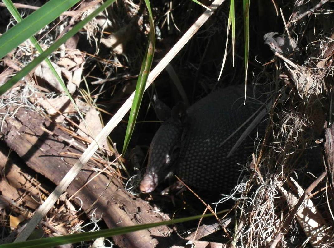
The island is a natural reserve and has no permanent settlements. On land I found a campsite, but what was marked as the path to the site was blocked by a fallen tree. I had to work my way through the undergrowth to get through. There was some animal here, I heard some heavy movements and some snorting, then he appeared - an armadillo

I was excited to see one, but I later realized that the place is full of them, I was able to video one of them digging for food:
When I rowed to shore this morning I realized I'm in oyster heaven. There's a huge oyster bank just south of me that's easily harvested when the tide is low.

I immediately returned to the boat to get bucket, hatchet and glove, and went to harvest my dinner:

After returning them to the boat I set off on a big hike on the island.


We anchored right at Fort Sumter, but after rolling miserably for 2 hours there I raised the anchor again and moved far up the Ashley River and anchored close to the Coast Guard Dock. It's calm here, I'm sure I'll sleep well.
Wednesday, October 19th
Charleston, SC
When I woke up I noticed that the anchorage I'm in is full of derelict or semi-abandoned boats. Judging by the amount of trash on them, and the growth of slime on their waterlines they might have been anchored here for years. Not a pretty sight...
Since I wanted to stay a day in Charleston I decided to spring for a marina to have access to shower, bathroom, land etc. I went up to 'The harborage' and got fuel and a slip. Only after I signed up and paid did they tell me that their showers and bathrooms are out of order from the hurricane. They offered portapotties - well I got a better bathroom on board!
They realized I was disappointed in it and offered me a ride across the bridge to a storage facility of them where they had a working shower, and I took them up on the offer. Afterwards I walked back across another bridge, but it took some effort to find sidewalks. This is 'merica - no sidewalks needed!
The weather is still wonderful and actually a bit warm to walk around at lunchtime, so I took a break and took off at 4pm and walked about 5 miles all over town. It's a charming city. Surprisingly small, actually, and without any skyscrapers. I hadn't realized Charleston has only 140000 inhabitants - that's smaller than my suburb of Naperville!

It's very walkable and full of pretty sights, old houses, parks and views. I got a phantastic tuna burger at 167 Raw, a place recommended on Tripadvisor. Next I got groceries and started walking back. By now it was close to 6:30 and things were already winding down. Not exactly Manhattan - but it's a Wednesday. By the time I got back to the boat it was pitch dark and after a snack I went to bed. Alarm is set at 3:50 am!
Thursday, October 20th
Charleston, SC to Ossabaw Island, Georgia

To catch the outgoing tide from Charleston meant a really early departure. I cast off the dock lines at 4:15 (with some fun due to the current). The harbor entry is very long and by the time I exited it was almost 5:30, and the tide about to shift. Outside was nice and still relatively calm. The usual long rollers weren't a problem once I had the sails up. The wind was weak and I had to motorsail the whole day. Still, progress was great and as I approached Savannah I decided to continue on, since the tide was still flowing out and again entering here now would have meant an hour of fighting the current, or more. It looked as if Ossabaw Island was a nice destination, and I got there just in time for sunset.
What gave me some worry was that I couldn't see some of the markers of the channel, and I had to proceed carefully, As a result I got to Bradley River, my intended anchorage, when it was pitch dark.
By now I'd been sailing for over 15 hours, and covered almost 100 nautical miles, my record. I was ready to have a quick dinner and go to bed. Fate had other plans:
As I carefully drove towards my planned anchorage the depth dropped alarmingly where it wasn't supposed to be shallow at all, according to the charts. I turned sharply around and decided to enter the actual river instead, thinking that there the water would be much deeper. According to the charts, the depth should have been 14 feet, but I ran aground!
According to Navionics, I'm in mid channel:

Look at Google Satellite:

There's a fricken sandbank there - not just shallow - it looks as if it's actually bare at low tide! No mention of it in the charts, at all...
Well, I didn't get too perturbed this time. I've been aground before. Since it's rising tide I should get off soon. My mistake was that I didn't count on the current pushing me further on the sandbank as the water rose. I had started making dinner when I realized what was happening. OK, time to inflate the dinghy and put the stern anchor in it. All in the pitch black night - I really should have taken my headlamp with me. I rowed the anchor out as far as I could, but the current was getting progressively stronger and making it pretty hard work. I got plenty wet - but it's warm here and that's the least of my worries.
Back on board I tightened the line and waited a bit for the tide to rise and set me free. Half an hour later I was ready. I pulled the line in and quickly tried to turn around and go back north, but before I was able to I hit the sand bank again. Gunning the engine in reverse brought on the overheat alarm buzzer. The cooling water inlet must have gotten plugged with mud and debris.
I shut down the engine and went to repeat the exercise, At least there's plenty tide here (8 feet today), so I have a few attempts. This time I decided to bring the anchor out as far as possible (about 120 feet). The current was even stronger now, and I had to really work hard to row against it with the line in tow and the anchor in the inflatable dingy. Eventually I got away enough and dropped the anchor and returned to the boat. First I unplugged the engine cooling water strainer, which was as expected full of stuff. Next I continued with dinner (I should have been starving by now but the excitement distracted me a bit) and after dinner I felt the boat starting to bounce and become free. I didn't want to try again too soon, but on the other hand if I'd wait for high tide and ran aground then I'd really be screwed.
So I waited another 20 mins, and then hauled in the anchor and managed to pull us free. The engine ran without trouble now and I quickly turned around and got away from the sandbank. We went another 100 meters and I dropped the anchor close to the little beach on the right, in plenty deep water. Finally clean up and go to bed.
Friday, October 21th
Ossabaw Island, Georgia
Small Craft Advisory on the ocean today, which means winds of 20-25 and gusts of 30+, including the matching waves. This suits me fine since I had planned a rest day here anyways, even before my grounding adventure yesterday. I moved up the river carefully behind a few small trees on shore and put a lot of anchor rode. The Caprice rides in circles because the current and the wind interplay with each other in funny ways. But I think I'm pretty well anchored and protected here. I plan to sail a long trip again tomorrow, to Cumberland Island, if conditions are as decent as predicted.
As I look out another cruising sailboat is appearing in this river, I have actually encountered very few cruisers yet, I'm a bit early for the 'southern migration'.
Ossabaw Island, Georgia to Jekyll Island, Georgia

Another early departure to catch the outgoing tide. Because I have my GPS track of yesterday, traversing the inlet even in the dark is no scary thing anymore. Nevertheless I breathed easier once out of the inlet and set a course towards Cumberland Island. The wind was still stronger than I anticipated, and the sea was rather 'lumpy' and making me a bit nauseous. I had the jib up partially for stability and partially for speed and made great progress. When it calmed down a bit I put the main sail up too and maintained speed. It was a bit chilly today, the wind still blowing from the north-west.
I had planned to go to Cumberland Island through St. Andrews inlet, but studying ActiveCaptain I found lots of warnings about shifting sand bars, missing markers and breakers. I'm a little timid about grounding in an inlet in somewhat rough conditions, especially on a falling tide.
I found an alternative, St Simons inlet a few miles north which leads to Brunswick and has a large, dredged channel. As I approached two huge car transport ships passed each other in the channel without problems.

I passed through the middle of the channel but noticed that the pelicans for some reason favor the green buoys. So on the next pair I went outside the deep channel (still plenty water under the keel) to get a better look at the family living on this buoy.
Entering here also had the advantage that I wouldn't have to fight the outgoing tide yet. From here we entered the ICW that separates Jekyll Island from the mainland, and a brisk current and the wind whisked me through here. I didn't want to try to cross the next inlet to Cumberland Island now, since the tide was falling and that crossing goes over a dangerous sandbank. I'll do it tomorrow on a rising tide.
The anchorage at the side of the ICW did need a few attempts before I found a spot that's deep enough (also deep enough at low tide!)

Jekyll Island, Georgia to Cumberland Island, Georgia

Today's trip was a quick, short one. I had to wait for near high tide though, because crossing St Andrew's inlet involves crossing a sandbank and almost entering the ocean. I was pretty careful since I'd read plenty of comments that this inlet can be hairy.
Once around the corner and back towards land the ride was smooth and quick, and I entered a river where I soon found a gorgeous anchorage and quickly rowed to land to walk around a bit.

The island is a natural reserve and has no permanent settlements. On land I found a campsite, but what was marked as the path to the site was blocked by a fallen tree. I had to work my way through the undergrowth to get through. There was some animal here, I heard some heavy movements and some snorting, then he appeared - an armadillo
I was excited to see one, but I later realized that the place is full of them, I was able to video one of them digging for food:
The path led me to a dirt road which I followed a bit north and then turned into a hiking path that was supposed to get me across the island to the Eastern beach. The traces of the hurricane linger, however. The path was occasionally blocked by fallen trees. Initially I managed to walk around them or crawl under them, but eventually it got so bad that I decided to retreat. It was becoming too late anyways, and I don't want to try to find my way back in the dark. Caprice was where I left her.
Tomorrow I plan to go for a long hike on the island, with proper shoes etc.
Monday, October 24th
Cumberland Island, Georgia
Cumberland Island, Georgia
When I rowed to shore this morning I realized I'm in oyster heaven. There's a huge oyster bank just south of me that's easily harvested when the tide is low.

I immediately returned to the boat to get bucket, hatchet and glove, and went to harvest my dinner:

After returning them to the boat I set off on a big hike on the island.

It's beautiful here. Much of the island is mixed woods (oaks and pines) with good paths. Today I didn't encounter any obstacles.

The beach is huge and of extremely fine sand, almost a powder. It's now everywhere...

Towards the end of the hike I for the first time spotted a feral horse. There's horse poop everywhere, and hoof prints, and I heard them on the beach last night, but here I saw the first one.

And then I came across this ugly fella - an opossum

After a hike of over 10 miles I returned to my critters and prepared them for grilling

Unfortunately my Magma Grill is in really poor shape, The supposedly stainless inside has so badly rusted that it fell apart, with the result that the heat in there doesn't spread well at all. Grilling the oysters evenly was almost impossible and took a lot of patience. They were delicious, but tomorrow I'll repeat this and steam them instead - that should work better.
Tuesday, October 25th
Cumberland Island, Georgia
I liked it so much here that I decided to spend another day. I don't expect to find anything like this in Florida, maybe I'll be wrong. At low tide I again went to the oyster beds and picked a selection of fat candidates. I found some kind of oyster 'planting' operation - lots of net bags, about the size of a sandbag, filled with many shells of oysters but with live ones growing on them. I assumed that this wasn't done for my benefit and left those bags alone. There were plenty oysters growing elsewhere.
This time I steamed them, using my big pressure cooker and the pasta colander. I had to do 5 batches (must have been 40-50 oysters) and they came out wonderful. That's going to be my standard way now, until I get a shucking knife and glove, because raw they would still be better.
Wednesday, October 26th
Cumberland Island, Georgia to Jacksonville Beach, Florida
Finally, today the day came when the Caprice got to Florida. Unbelievable.
There were two choices - go down to St Mary's Inlet and turn right and into the ICW and stay inside. Or, leave into the ocean at St Mary's and go down about 20 miles outside, and reenter at St John's.
The problem with the first choice was the currents caused by the tides. While I was approaching the inlet, the tide was going out, pushing me along at great speed. But, after turning into the ICW would have made that same current slow me to a crawl. Worse, by the time I'd approach St John's inlet on the ICW, the tide was going to be coming in. slowing me again.
On the other hand, if I left at St Mary's, the tide was going to suck we right out of the inlet. and by the time I'd arrive at St John's, the tide would just about start going in.
I had to go outside.

The predicted wind and waves hadn't sounded too bad, but as I went through the inlet they seemed worse than I had expected. The outgoing tide and incoming waves were creating a confused mess of sometimes way larger waves than were comfortable. If the rhythm is bad, the Caprice rides down one wave and crashes right into the next before she can ride up, slowing her with a strong jolt. Here's the graph of speed from lifting anchor to exiting and turning south:

Speed keeps increasing nicely all the way to the begin of the inlet - but then it starts being chopped up by the wave action.
A coast guard boat came by and kept a watch at me for a few minutes, to make sure I was OK. I appreciated the care, but I couldn't get the radio to thank the guys since I was busy steering.
I was very glad to turn the corner south, although that meant at times terrible rolling from the waves that were now hitting from the left side. Rolling by +/- 15 degrees meant I wasn't able to do much but just steer as good as I could. When really bad waves hit the roll was sometimes +/- 20 degrees and stuff in the cabin started falling off the shelves and bunks.
It got slightly better once out in deeper water and I made excellent speed, since I had the jib up for stability and drive. As hoped I got into St John's, the inlet for Jacksonville, just as the tide changed and speed increased steadily to my final destination today, Jacksonville Beach.


At Jacksonville Beach a colleague from work and his lovely wife and daughter met me and treated me to a great dinner in the cockpit of the Caprice. I fear I might have talked too much, having not been around people for about a week...
Thursday, October 27th
Since this was a shorter trip I was able to go buy some more provisions and diesel before taking off to St Augustine. The ICW divides the villas on the ocean side form the wilderness in the west.


I anchored in the mooring field and got a shuttle to shore (it would have been a long row, especially against the current, with my dinghy). The town is pretty and proud of its heritage - but it felt a bit Disneyfied to me. I'd enjoy those places more if I had my Admiral with me I believe.
The town was guarded in Spanish times by a fort overlooking the inlet

The most beautiful building I saw was the former Flagler Hotel, now housing Flagler University

Friday, October 28th
St Augustine to New Smyrna Beach

Talking to Dave on the phone I realized I made a big miscalculation about how many days I should take to my final destination of this phase - I've miscalculated by a full day. I will have to go faster and further each day from now on to make it in time for my booked return flight from Palm Beach.
Since the winds are forecast to be blowing strong from the W-NW for the next three days, I can hopefully use them to speed my journey. Also, I calculated that the currents will be favorable if I leave St Augustine early, because I'll get a push and a pull when I reach the next inlet.
Things went exceedingly well indeed - the wind was just strong enough to give me some extra drive, and the currents were helping. I was able to get a big step closer to my goal.
Along the way I started seeing more and more wrecks - and I assume these are from poorer people who just can't afford to have their boats salvaged. The hurricane really hit them,


I anchored in a creek just before New Smyrna and had a calm night, even though the wind was blowing pretty fierce.

More wrecks - although this one might have sunk before

The wind was still stronger today and that suited me just fine. I put up the main sail with a single reef and the small headsail (the only one I have since I returned the one I bought from Minney's)
Right after leaving New Smyrna I could see the 'Vehicle Assembly Building', one of the largest buildings in the world.

The traffic on the ICW was intensifying - maybe it's because of the weekend. Whenever a powerboat passed me I had to do a hook maneuver to hit his wake head on. Thankfully all of the boaters I encountered were careful to slow down before they passed me.
Some of the way we were going through pretty large lagoons, and the waves kicked up here were a bit like in the Pamlico River. I enjoyed the quick ride but could have done without the rolling. Eventually however the lagoons narrowed, and by the time I passed Cocoa I was able to switch off the motor and run the rest of the way by sail only. This part of the Indian River is great for sailing because it's wide and deep enough in most parts. In other areas one has to be very careful to stay in the channel because it's very shallow when you get away from it.

Another great sailing day, it was blowing strong and the river was narrow enough to not kick up much of a chop. I wasn't the only one enjoying the ride.

When I reached Orchid Island I had to use the engine to help speed us up, because here the river meanders through some wooded area and shields too much of the wind.
As I got close to Jensen Beach I saw an island that looked odd - the buildings on there seemed rather small compared with the big mansions I had been seeing mostly, but they looked colorful.

I looked it up on Google Maps - look at the density of the houses!

It turns out this is a development of vacation homes for rent. It looks a bit too dense for me...
Monday, October 31th
Jensen Beach to Indiantown
Marina prices in southern Florida are very high, but there's one economical marina, far inland, that I've heard good things about. This is my destination for this leg of the trip.

The wind from yesterday was still blowing strong, and since today's trip was relatively short I immediately switched the motor off after leaving the anchorage and sailed south to St Lucie inlet. It was again perfect sailing weather. The incoming tide slowed me a bit, but I knew that once I turned the corner inland this same current would push me. And it did, but as I was getting fluky winds from all the land around me I had to switch to motorsailing.
'Old Roosevelt bascule bridge', according to Active Captain, opens on the hour and half hour, so I timed my speed carefully to arrive at the best time, only to find that the bridge actually opens on demand as well, like most here.
Stuart is a great yacht harbor and is the begin of the St Lucie canal. There's a lock at the beginning where I had to wait a little, and because I was going through a lock alone for the first time I had prepared lines and a tactic for staying straight - but in the end it turned out that here the lock master throws lines for you to make fast and that it's all really easy,
I got to Indiantown without any trouble and got everything arranged and started cleaning.
I walked around a bit and met the local pet. He was hanging out on one of the boat ramps.

Tomorrow I plan to visit my friends Danny and Su Ling, and then back to Chicago.
The Caprice is really close to the holy land of cruising, the Bahamas.

Tuesday, November 1st
Indiantown
After cleaning up and taking the headsail down I walked the work yard a bit and today I found Matt and Jessica on Daze Off, a couple from Michigan that write a nice blog I've been following a long time. It was very nice to meet them in person, and I hope that next year on my return they will still be here so I can treat them to some beers.
Initially the marina had said they would haul the Caprice only on Wednesday and told me they'd have to move the boat on that day from the wall to the lift, and asked me to sign a work order for that task (with the associated costs). However, they now told me that plans had changed and that I could bring the boat to the crane already and they'd lift it soon. Good news.
I wanted to take a taxi or Uber to West Palm Beach to Danny and SuLing, but this suddenly turned into an unexpected problem - the only taxi company in town had no drivers and Uber kept telling me that no cars were available. I called Danny to tell him that I'd be late or maybe not at all able to meet them, and he immediately jumped into the car with SuLing to get me - a ride of 45 miles! What a friend, I was super happy to see them.


The alligator didn't seem to mind us


We drove to West Palm beach and had some excellent lunch at a Cuban restaurant. It was great fun to catch up on stories with them. Danny was the owner of an Alberg 30 at Montrose harbor when he lived in Chicago, and I had many fun rides on his boat. He only sold his boat, the 'Aquila', when he moved to Florida permanently a few years ago. We miss him a lot in Chicago.
After that they gave me a lift to the airport and this phase of the Caprice journey was over,

The beach is huge and of extremely fine sand, almost a powder. It's now everywhere...

Towards the end of the hike I for the first time spotted a feral horse. There's horse poop everywhere, and hoof prints, and I heard them on the beach last night, but here I saw the first one.

And then I came across this ugly fella - an opossum

After a hike of over 10 miles I returned to my critters and prepared them for grilling

Unfortunately my Magma Grill is in really poor shape, The supposedly stainless inside has so badly rusted that it fell apart, with the result that the heat in there doesn't spread well at all. Grilling the oysters evenly was almost impossible and took a lot of patience. They were delicious, but tomorrow I'll repeat this and steam them instead - that should work better.
Tuesday, October 25th
Cumberland Island, Georgia
I liked it so much here that I decided to spend another day. I don't expect to find anything like this in Florida, maybe I'll be wrong. At low tide I again went to the oyster beds and picked a selection of fat candidates. I found some kind of oyster 'planting' operation - lots of net bags, about the size of a sandbag, filled with many shells of oysters but with live ones growing on them. I assumed that this wasn't done for my benefit and left those bags alone. There were plenty oysters growing elsewhere.
This time I steamed them, using my big pressure cooker and the pasta colander. I had to do 5 batches (must have been 40-50 oysters) and they came out wonderful. That's going to be my standard way now, until I get a shucking knife and glove, because raw they would still be better.
Wednesday, October 26th
Cumberland Island, Georgia to Jacksonville Beach, Florida
There were two choices - go down to St Mary's Inlet and turn right and into the ICW and stay inside. Or, leave into the ocean at St Mary's and go down about 20 miles outside, and reenter at St John's.
The problem with the first choice was the currents caused by the tides. While I was approaching the inlet, the tide was going out, pushing me along at great speed. But, after turning into the ICW would have made that same current slow me to a crawl. Worse, by the time I'd approach St John's inlet on the ICW, the tide was going to be coming in. slowing me again.
On the other hand, if I left at St Mary's, the tide was going to suck we right out of the inlet. and by the time I'd arrive at St John's, the tide would just about start going in.
I had to go outside.

The predicted wind and waves hadn't sounded too bad, but as I went through the inlet they seemed worse than I had expected. The outgoing tide and incoming waves were creating a confused mess of sometimes way larger waves than were comfortable. If the rhythm is bad, the Caprice rides down one wave and crashes right into the next before she can ride up, slowing her with a strong jolt. Here's the graph of speed from lifting anchor to exiting and turning south:

Speed keeps increasing nicely all the way to the begin of the inlet - but then it starts being chopped up by the wave action.
A coast guard boat came by and kept a watch at me for a few minutes, to make sure I was OK. I appreciated the care, but I couldn't get the radio to thank the guys since I was busy steering.
I was very glad to turn the corner south, although that meant at times terrible rolling from the waves that were now hitting from the left side. Rolling by +/- 15 degrees meant I wasn't able to do much but just steer as good as I could. When really bad waves hit the roll was sometimes +/- 20 degrees and stuff in the cabin started falling off the shelves and bunks.
It got slightly better once out in deeper water and I made excellent speed, since I had the jib up for stability and drive. As hoped I got into St John's, the inlet for Jacksonville, just as the tide changed and speed increased steadily to my final destination today, Jacksonville Beach.


At Jacksonville Beach a colleague from work and his lovely wife and daughter met me and treated me to a great dinner in the cockpit of the Caprice. I fear I might have talked too much, having not been around people for about a week...
Thursday, October 27th
Jacksonville Beach, Florida to St Augustine
Since this was a shorter trip I was able to go buy some more provisions and diesel before taking off to St Augustine. The ICW divides the villas on the ocean side form the wilderness in the west.


I anchored in the mooring field and got a shuttle to shore (it would have been a long row, especially against the current, with my dinghy). The town is pretty and proud of its heritage - but it felt a bit Disneyfied to me. I'd enjoy those places more if I had my Admiral with me I believe.
The town was guarded in Spanish times by a fort overlooking the inlet

The most beautiful building I saw was the former Flagler Hotel, now housing Flagler University

St Augustine to New Smyrna Beach

Talking to Dave on the phone I realized I made a big miscalculation about how many days I should take to my final destination of this phase - I've miscalculated by a full day. I will have to go faster and further each day from now on to make it in time for my booked return flight from Palm Beach.
Since the winds are forecast to be blowing strong from the W-NW for the next three days, I can hopefully use them to speed my journey. Also, I calculated that the currents will be favorable if I leave St Augustine early, because I'll get a push and a pull when I reach the next inlet.
Things went exceedingly well indeed - the wind was just strong enough to give me some extra drive, and the currents were helping. I was able to get a big step closer to my goal.
Along the way I started seeing more and more wrecks - and I assume these are from poorer people who just can't afford to have their boats salvaged. The hurricane really hit them,


I anchored in a creek just before New Smyrna and had a calm night, even though the wind was blowing pretty fierce.
Saturday, October 29th
New Smyrna Beach to Melbourne Beach
New Smyrna Beach to Melbourne Beach

More wrecks - although this one might have sunk before

The wind was still stronger today and that suited me just fine. I put up the main sail with a single reef and the small headsail (the only one I have since I returned the one I bought from Minney's)
Right after leaving New Smyrna I could see the 'Vehicle Assembly Building', one of the largest buildings in the world.

The traffic on the ICW was intensifying - maybe it's because of the weekend. Whenever a powerboat passed me I had to do a hook maneuver to hit his wake head on. Thankfully all of the boaters I encountered were careful to slow down before they passed me.
Some of the way we were going through pretty large lagoons, and the waves kicked up here were a bit like in the Pamlico River. I enjoyed the quick ride but could have done without the rolling. Eventually however the lagoons narrowed, and by the time I passed Cocoa I was able to switch off the motor and run the rest of the way by sail only. This part of the Indian River is great for sailing because it's wide and deep enough in most parts. In other areas one has to be very careful to stay in the channel because it's very shallow when you get away from it.
Sunday, October 30th
Melbourne Beach to Jensen Beach
Melbourne Beach to Jensen Beach

Another great sailing day, it was blowing strong and the river was narrow enough to not kick up much of a chop. I wasn't the only one enjoying the ride.

When I reached Orchid Island I had to use the engine to help speed us up, because here the river meanders through some wooded area and shields too much of the wind.
As I got close to Jensen Beach I saw an island that looked odd - the buildings on there seemed rather small compared with the big mansions I had been seeing mostly, but they looked colorful.

I looked it up on Google Maps - look at the density of the houses!

It turns out this is a development of vacation homes for rent. It looks a bit too dense for me...
Monday, October 31th
Jensen Beach to Indiantown
Marina prices in southern Florida are very high, but there's one economical marina, far inland, that I've heard good things about. This is my destination for this leg of the trip.

The wind from yesterday was still blowing strong, and since today's trip was relatively short I immediately switched the motor off after leaving the anchorage and sailed south to St Lucie inlet. It was again perfect sailing weather. The incoming tide slowed me a bit, but I knew that once I turned the corner inland this same current would push me. And it did, but as I was getting fluky winds from all the land around me I had to switch to motorsailing.
'Old Roosevelt bascule bridge', according to Active Captain, opens on the hour and half hour, so I timed my speed carefully to arrive at the best time, only to find that the bridge actually opens on demand as well, like most here.
Stuart is a great yacht harbor and is the begin of the St Lucie canal. There's a lock at the beginning where I had to wait a little, and because I was going through a lock alone for the first time I had prepared lines and a tactic for staying straight - but in the end it turned out that here the lock master throws lines for you to make fast and that it's all really easy,
I got to Indiantown without any trouble and got everything arranged and started cleaning.
I walked around a bit and met the local pet. He was hanging out on one of the boat ramps.

Tomorrow I plan to visit my friends Danny and Su Ling, and then back to Chicago.
The Caprice is really close to the holy land of cruising, the Bahamas.

Tuesday, November 1st
Indiantown
After cleaning up and taking the headsail down I walked the work yard a bit and today I found Matt and Jessica on Daze Off, a couple from Michigan that write a nice blog I've been following a long time. It was very nice to meet them in person, and I hope that next year on my return they will still be here so I can treat them to some beers.
Initially the marina had said they would haul the Caprice only on Wednesday and told me they'd have to move the boat on that day from the wall to the lift, and asked me to sign a work order for that task (with the associated costs). However, they now told me that plans had changed and that I could bring the boat to the crane already and they'd lift it soon. Good news.
I wanted to take a taxi or Uber to West Palm Beach to Danny and SuLing, but this suddenly turned into an unexpected problem - the only taxi company in town had no drivers and Uber kept telling me that no cars were available. I called Danny to tell him that I'd be late or maybe not at all able to meet them, and he immediately jumped into the car with SuLing to get me - a ride of 45 miles! What a friend, I was super happy to see them.


The alligator didn't seem to mind us


We drove to West Palm beach and had some excellent lunch at a Cuban restaurant. It was great fun to catch up on stories with them. Danny was the owner of an Alberg 30 at Montrose harbor when he lived in Chicago, and I had many fun rides on his boat. He only sold his boat, the 'Aquila', when he moved to Florida permanently a few years ago. We miss him a lot in Chicago.
After that they gave me a lift to the airport and this phase of the Caprice journey was over,